News Center
News CenterTyphoon "Lichma" Strong Attack
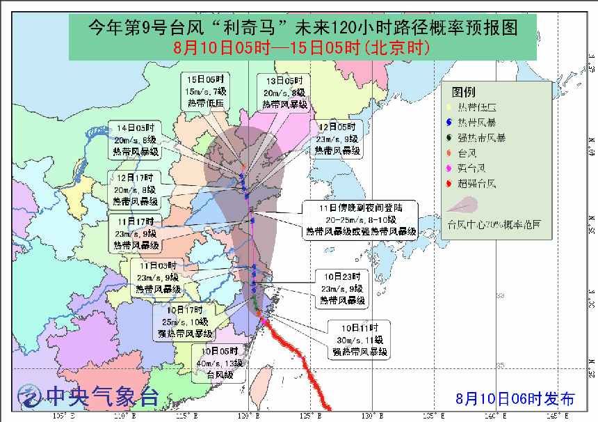
Time:2019-08-10 Source: Central Meteorological Observatory
Affected by the "Litchma" typhoon weather, heavy rains
occurred in Jiangsu, Zhejiang, Shanghai and other places. It is expected that "Litchma" will move
northward at a speed of about 15 kilometers per hour, and the intensity will gradually weaken
through Zhejiang and Jiangsu. After that, it will move into the western part of the Yellow Sea
around noon tomorrow, and will land again on the southern coast of the Shandong Peninsula from
tomorrow evening to night (tropical storm or strong tropical storm class, 8-10, 20-25 m / s).
From 08:00 to 11:00 on the 10th, the bus strait, the
northern part of the Taiwan Strait, the east of Taiwan, the East China Sea, the Hangzhou Bay, the
Yangtze River estuary, the Yellow Sea, the Bohai Bay and the northern part of Taiwan Island,
north-central Fujian, Zhejiang, Shanghai, The coastal areas of Jiangsu and the southern part of the
Shandong Peninsula will have 6-8 winds, including 9-10 in the southwestern part of the Yellow Sea,
the western part of the East China Sea, the Yangtze River estuary, the Hangzhou Bay, and the coastal
areas of Zhejiang, Shanghai, and southern Jiangsu. The winds in the central and northern coastal
areas of Zhejiang Province are 11-12, and the gusts can reach 13-14. The following is a chart of the
future 120-hour probability forecast issued by the Central Meteorological Observatory.
All the staff of Lanchang Enterprise reminded the majority of friends to close the doors and windows at home and try to reduce the risk of typhoon weather.